Introduction: Why real‑time in‑plume data matters
Wildfires can change their behavior very fast. A sudden wind shift can turn a safe area into a dangerous one and trap crews. Standard weather forecasts often miss these sudden, local changes near the fire. Directly measuring the air inside the plume (the thick column of smoke) gives commanders fast, clear information they can use to keep people safe.
What the study did
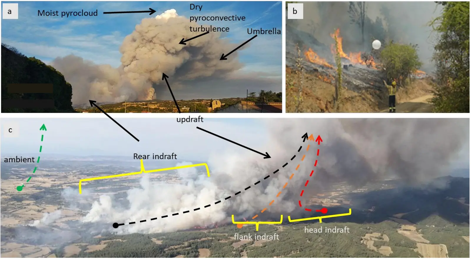
Researchers ran field campaigns from 2021 to 2025 and launched 156 radiosondes into active fire plumes and nearby ambient air across Spain, Chile, Greece, and the Netherlands to see how the fire changes local weather. They used a paired approach: one sonde goes through the plume and another measures nearby ambient air. Comparing those two profiles shows how the fire changes wind, temperature, and humidity in real time.
Main findings
- In‑plume measurements found sudden changes in wind speed, wind direction, temperature, and humidity that regional weather models did not show.
- Strong updrafts from the fire and the air flowing back toward the fire are clear signs that fire behavior can escalate quickly.
- These in‑plume signals can act as early warnings so commanders can move crews or change plans before conditions get dangerous.
Why radiosondes are useful for firefighter crews
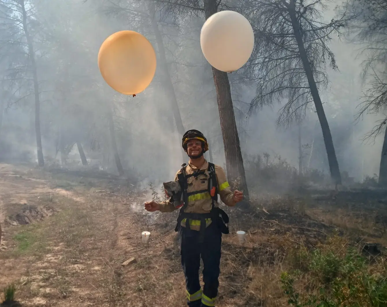
Radiosondes are small measuring instruments attached to air-balloons that rise through the smoke and send data back instantly. They measure wind, temperature, and humidity as they climb. This direct, vertical picture of the atmosphere near the fire lets teams spot risky changes earlier than with forecasts alone.
Why the Windsond S1H2 was used
The study tested several tools including drones, helicopter sensors, and different radiosondes, and chose the Sparv Windsond S1H2 because it matched the field needs for in‑plume work: reliable telemetry, ruggedness, and good data quality while flying through smoky updrafts.
Newer hardware to consider
Sparv has since released the Windsond S2, which is lighter, easier to use, and more robust than the S1 while offering improved data quality for field teams considering in‑plume profiling.
Simple steps teams can adopt now
- Use a dual‑sonde method
- Launch one sonde into the plume and one into nearby ambient air to get a direct comparison that reveals fire‑induced changes.
- Set clear decision triggers
- Define specific changes in wind or temperature that will prompt crew movement or wider safety measures.
- Train quickly and run pilots
- Practice a short checklist for launch, telemetry checks, and fast interpretation during a controlled or low‑risk exercise.
- Combine data sources
- Use sonde data together with ground weather stations, lookout reports, and satellite or drone feeds for a fuller picture.
A short pilot checklist for field teams
- Gear: radiosonde units, spare batteries, reliable telemetry receiver, GPS sync.
- Launch plan: choose one point upwind for ambient and one point in the plume indraft for in‑plume.
- Quick checks: confirm telemetry link and that both sondes are sending data before release.
- Interpretation: look for abrupt wind direction changes, rapid vertical wind shear, and sudden humidity drops in the first minutes.
- Action: if thresholds are crossed, notify command and move crews to preplanned safety zones.
Research and operational value
The dataset and methods from the study support better plume nowcasting and help validate high‑resolution models that predict dangerous fire behavior. Making paired radiosonde profiles part of standard monitoring can reduce surprises on the fireline and improve the safety of crews and resources.
Conclusion: Windsond is a practical safety tool
Launching radiosondes into wildfire plumes is a practical, evidence‑backed way to get fast, local atmospheric data that can save lives. Agencies should pilot the dual‑sonde approach, test the Windsond family or similar sondes, and integrate the data into command displays so decisions are based on what the air is actually doing near the fire.
About the author
Phillip Chilson
Atmospheric Physicist & Customer Service
Phillip applies meteorological expertise to support instrument development, deployment, and data collection. Ensures high-quality data from the Sparv instrumentation suite. Partners with clients to design customized sampling strategies.