Executive Summary
Sparv Embedded partnered with Linköping University to create a lightweight, high-precision methane (CH₄) monitoring kit for small drones. By integrating Aeris Technologies’ MIRA Series mid-infrared sensor—capable of detecting sub-ppb variations—with Sparv’s Sparvio SKH1 data logger, the complete payload weighs just 1.8 kg and enables flights of around 10 minutes. This setup delivers 0.0001 ppm resolution, easily mapping background levels near 2 ppm. Real-time GPS-tagged data from CH₄, ultrasonic wind, temperature, humidity, and positional sensors are streamed to a ground station for live mapping and subsequent flux calculations. Given methane’s greenhouse potency—84 times that of CO₂ over 20 years—this agile UAV solution fills a critical gap in industrial and regulatory monitoring. The platform not only locates emission hotspots but also quantifies gas flow, paving the way for broader environmental surveillance and rapid-response field campaigns.
Key Learnings
- Aeris MIRA Series delivers sub-ppb methane sensitivity in an ultraportable package.
- UAV payload (1.8 kg) sustains 10-minute flights on small quadcopters for boundary-layer sampling.
- Resolution of 0.0001 ppm maps background CH₄ levels (~2 ppm) and detects minor plumes.
- Real-time telemetry with GPS and wind data enables on-the-fly hotspot localization and flux estimation.
- Compact design and low helium use reduce logistical and operational costs.
- System extensibility supports additional sensors (e.g., Li-Cor 3D anemometer) and longer-range missions.
Introduction to UAV-Based Methane Monitoring
Methane emissions are a leading driver of near-term climate warming, with an 84 × greater greenhouse effect than carbon dioxide over two decades. Yet industrial and regulatory monitoring often overlook diffuse CH₄ sources. UAV-mounted sensors can rapidly survey large areas, pinpoint leaks, and quantify fluxes with far greater spatial resolution than stationary chambers.
Integrating Aeris MIRA Series Sensor with Sparvio
Aeris Technologies’ MIRA Series gas analyzers employ mid-infrared absorption spectroscopy for ultra-high sensitivity. Their proprietary long-path tunable diode laser spectrometer achieves sub-ppb accuracy in a compact, low-power module. Sparv Embedded adapted the MIRA Strato variant—optimized for drone use—into the Sparvio SKH1 logging system. This integration timestamps and logs CH₄ concentration alongside GPS position, wind speed/direction (via an ultrasonic sensor), temperature, and humidity.
UAV Payload and Flight Performance
- Total payload weight: 1.8 kg after UAV adaptation
- Flight duration: ~10 minutes on a mid-size quadcopter; further weight optimization possible
- Sampling altitude: Configurable; ideal for boundary-layer and near-ground plume detection
- Resolution: 0.0001 ppm (0.1 ppb) over a background of ~2 ppm
This lightweight payload allows researchers to hover directly above suspected leak sites, gathering high-density CH₄ profiles without the need for towers or tethered systems.
Real-Time Data Logging and Mapping
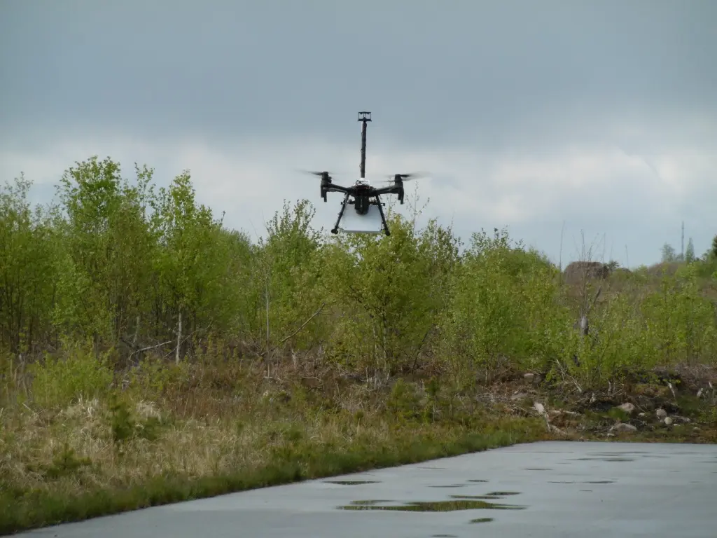
During field demo flights (e.g., May 15th tests), the white Aeris sensor hung beneath a DJI Matrice-210, linked to Sparvio’s telemetry radio. Data streams to a rugged ground station, where live Google Earth overlays display flight tracks colored by CH₄ concentration. Post-flight analysis uses synchronized wind vectors and positional data to compute both emission source locations and volumetric flow rates.
Environmental Impact and Applications
- Leak detection: Oil & gas pipelines, landfills, wastewater treatment facilities
- Flux quantification: Agricultural emissions, natural seepage areas, fracking sites
- Rapid-response campaigns: Deployments ahead of wildfires or industrial accidents
- Academic research: High-resolution atmospheric chemistry and local-scale climate feedback studies
By democratizing methane monitoring, this system helps industries and regulators close data gaps, prioritize mitigation, and verify emission reductions.
Future Outlook
Continued miniaturization of the MIRA core and advances in battery density will extend flight times and expand payloads. Adding optical gas imaging or multi-gas arrays can further enrich datasets. As UAV regulations evolve, such agile sensing platforms will become indispensable tools in meeting global climate goals.
Sources:
[1] “High resolution methane measurements from UAVs,” Aeris Technologies, Jun 1, 2019. High resolution methane measurements from UAVs - Aeris Technologies
[2] “Aeris – MIRA Series – Gas Analyzer,” Environmental-Expert / Sparv Embedded AB. Aeris MIRA Series Gas Analyzer
About the author

Mattias Wilzén
Head of Finance & Customer Accounts
Oversees financial performance and ensures smooth operations for our customers, from order to delivery and ongoing support.